
Pokhara Sub-Metropolitan City (Nepali: पोखरा उपमहानगरपालिका Pokhara Up-Mahanagarpalika) is a city of close to 200,000 inhabitants in central Nepal located at 28.25°N, 83.99°E, 198 km west of Kathmandu. It is the third largest city of Nepal after Kathmandu and Biratnagar. It is the Headquarters of Kaski District, Gandaki Zone and the Western Development Region. It is also one of the most popular tourist destinations of the country.
Geography
Pokhara is situated in the northwestern corner of the Pokhara Valley, which is a widening of the Seti Gandaki valley. The Seti River and its tributaries have dug impressive canyons into the valley floor, which are only visible from higher viewpoints or from the air. To the east of Pokhara is the municipality of Lekhnath, a recently established town in the valley.
In no other place do mountains rise so quickly. In this area, within 30 km, the elevation rises from 1,000 m to over 7,500 m. Due to this sharp rise in altitude the area of Pokhara has one of the highest precipitation rates of the country (over 4,000 mm/year). Even within the city there is a noticeable difference in the amount of rain between the south of the city by the lake and the north at the foot of the mountains.
The climate is sub-tropical but due to the elevation the temperatures are moderate: the summer temperatures average between 25–35 °C, in winter around 5–15 °C.
In the south the city borders on Phewa Tal (lake) (4.4 km² at an elevation of about 800 m above sea level), in the north at an elevation of around 1,000 m the outskirts of the city touch the base of the Annapurna mountain range. From the southern fringes of the city 3 eight-thousanders (Dhaulagiri, Annapurna, Manaslu) and, in the middle of the Annapurna range, the Machapuchhre (Nepali language: Machhapuchhre: 'Fishtail') with close to 7,000 m can be seen. This mountain dominates the northern horizon of the city and its name derives from its twin peaks, not visible from the south. The porous underground of the Pokhara valley favours the development of caves of which three prominent ones can be found within the city: Mahendra, Bat and Gupteswor. In the south of the city, a tributary of the Seti coming from Fewa Tal disappears at Patale Chhango (Nepali for Hell's Falls, also called Devi's or David's Falls, after someone who supposedly fell into the falls) into an underground gorge, to reappear 500 metres further south.
story
Pokhara lies on an important old trading route between Tibet and India. In the 17th century it was part of the influential Kingdom of Kaski which again was one of the Chaubise Rajaya (24 Kingdoms of Nepal) ruled by a branch of the Shah Dynasty. Many of the mountains around Pokhara still have medieval ruins from this time. In 1752 the King of Kaski invited Newars from Bhaktapur to Pokhara to promote trade. Their heritage can still be seen in the architecture along the streets in Bhimshen Tol (Old Pokhara). Hindus, again, brought their culture and customs from Kathmandu and settled in the whole Pokhara valley. In 1786 Prithvi Narayan Shah added Pokhara into his kingdom. It had by then become an important trading place on the routes from Kathmandu to Jumla and from India to Tibet.
Originally Pokhara was largely inhabitated by Brahmins, Chhetris and Thakuris (the major villages were located in Parsyang, Malepatan, Pardi and Harichowk areas of modern Pokhara) and the Majhi community near the Fewa Lake. Later in the 18th century A.D the newars of Bhaktapur migrated to Pokhara and settled near main business locations such as Bindhyabasini temple, Nalakomukh and Bhairab Tole. The establishment of a British recruitment camp brought larger Magar and Gurung communities to Pokhara. At present the Khas (Brahmin, Chhetri, Thakuri and Dalits), Gurung (Tamu) and Magars form the dominant community of Pokhara. There is also a sizeable population of Newaris in Pokhara. A small muslim community is located on eastern fringes of Pokhara generally called Miya Patan.
The nearby hill villages around Pokhara has a mixed community of Khas and Tamu. Small Magar communities are also present mostly in the southern outlying hills. Newari community is almost non-existent in the villages of outlying hills outside the Pokhara city limits.
From 1959 to 1962 some 300,000 refugees fled to Nepal from neighbouring Tibet after it was annexed by China. Four refugee camps were established in and around Pokhara: Tashipalkhel, Tashiling, Paljorling and Jambling. These camps have evolved into well built settlements, each with a gompa (Buddhist monastery), chorten and its particular architecture, and Tibetans have become a visible minority in the city.
Until the end of the 1960s the town was only accesible by foot and it was considered even more a mystical place than Kathmandu. The first road was completed in 1968 (Siddhartha Highway) after which tourism set in and the city grew rapidly. The area along the Phewa lake has developed into one of the major tourism hubs of Nepal.
Structure

Pokhara spans 8 km from north to south and 6 km from east to west but, unlike Kathmandu, it is quite loosely built up and still has much green space. The Seti Gandaki flowing through the city from north to south divides the city roughly in two halves with the down-town area of Chipledunga in the middle, the old town centre of Bagar in the north and the tourist district of Lakeside (Baidam) in the south all lying on the western side of the river. The gorge through which the river flows is crossed at five points, the major ones are (from north to south): K.I. Singh Pul, Mahendra Pul and Prithvi Highway Pul. The eastern side of town is mainly residential.
About half of all tourists visiting Pokhara are there for the start or end of a trek to the Annapurna Base Camp and Mustang.
Lake Phewa was slightly enlarged by damming. It is in danger of silting up because of the inflow during the monsoon. The outflowing water is partially used for hydro power. The dam collapsed in the late 1970s and has been rebuilt. The power plant is located about 100 m below at the bottom of the Phusre Khola gorge. Water is also diverted for irrigation into the southern Pokhara valley.
The eastern Pokhara Valley receives irrigation water through a canal running from a reservoir by the Seti in the north of the city. Phewa lake is also used for commercial fishing. The tourist area is along the north shore of the lake (Baidam, Lakeside and Damside). It is mainly made up of little shops, little hotels, restaurants and bars. The larger hotels can be found on the southern and south-eastern fringes of the city, from where the view of the mountains is best. To the east of the valley, in Lekhnath, are several smaller lakes, the largest being Begnas Tal and Rupa Tal. Begnas Tal is also known for its fishery projects. There are no beaches in the valley, but one can rent boats in Phewa and Begnas Tal.
Tourism and economy

After the annexation of Tibet by China that led to the Indo-China war the trading route to India became defunct. Today only few caravans from Mustang still arrive in Bagar.
Pokhara has become a major tourist hub of Nepal, more than making up for the loss of its trading importance. The city offers a combination of nature and culture and is mostly known as the gateway to the trekking route "Round Annapurana", which is usually a trek of 25 days.
Pokhara is quite a modern city with only few touristic attractions in the town itself. Most interesting is the old centre in the north of the city (Bagar, Purano Bazar) where still many old shops and warehouses in the Newari style can be found. Although more seldom, mule caravans still arrive there from Mustang.
Temples worth visiting in the older part of town are Bindhyabasini temple and Bhimsen temple. Another temple, Barahi temple, is located on an island in the Phewa lake, accessible only by boats.
The modern commercial city centre at Chiple Dhunga and Mahendrapul (now called Bhimsen Chowk, named after a Shahid (Martyr) in Jana-aandolan II, April, 2006) is halfway between the lake and Purano Bazar, the old centre. Apart from this there are several subcentres in other parts of town: in the north in Bagar, in the south between Prithvi Chok and Srijana Chok (mainly hardware stores), and in the east, on the other side of the Seti, in Ram Bazar.

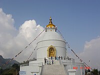
On a hill overlooking Phewa Tal from the south is the World Peace Stupa (at 1,113 m) QTVR built in 1996 with a view of the lake, across the city and of the snow peaked mountain ranges of Manaslu, Annapurna and Dhaulagiri Himal.
The best viewpoint of Pokhara is Sarangkot (1,600 m) and Thulakot (in Lekhnath a part of famous Royal Trek from where four lakes Phewa, Begnas, Khaste and Dipang and whole Annapurna range can be seen) to the west of the city. Paths and a road lead almost to the top of Sarangkot with an excellent view of the mountains and the city. On the summit of Sarankot there is a Buddhist stupa/monastery, which also attracts many tourists.

The major touristic attractions of Pokhara are its scenic views in and around town. Many of them are not mentioned in guides or maps. The Seti Gandaki (White Gandaki) and its tributaries have created spectacular gorges in and around the whole city. The Seti gorge runs through the whole city from north to south. At places it is only a few metres wide and the river is so far down below that, at places it is not visible or audible.

In the middle of the city, the gorge widens to a canyon looking like a crater. In the north and south, just outside town, the rivers created canyons, in some places 100 m deep. These canyons extend through the whole Pokhara Valley. Viewpoints are not easy to find. One place is the Prithvi Narayan Campus and the other side at the foot of Kahu Danda, where several rivers and canyons join. Behind the INF-Compound (Tundikhel) one can see the Seti River disappear into a small slit of a wall about 30 metres high which is especially impressive in monsoon. Betulechaur in the far north of Pokhara is known for the musicians caste of the Gaines.

No comments:
Post a Comment